Monday’s update for Powder River, Fox, and Bob Creek Fires in Baker County
By Logan Bagett on Monday, August 3rd, 2026 in More Top Stories Northeastern Oregon News
HUNTINGTON – (UPDATE 8/3 from Southwest Area Incident Management Team)
Work continues with patrols, containment, and movement of resources
Daily Update for Fox, Bob Creek and Powder River Fires: August 3, 2026
Fox Fire
Acres: 78,815 Containment: 46% Start Date: July 23, 2026 Location: 12 miles northeast of Huntington, Oregon
Cause: Undetermined Fuels: Grass and Timber Personnel: 409
On the northwest side, the Fox Fire continued to be active in the area east of Sisley Creek and west of Hibbard Creek. Moving north towards Forsea River Ranch, the Fox Fire also moved across Daly Creek. Crews worked to keep that part of the fire east of Sugarloaf Mountain/Manning Creek Road. In these two active areas, helicopters were able to support ground crews with water drops throughout the day. Also, hand crews in the Lookout Mountain/Hibbard Creek roads area were able to connect handlines, connecting one from the south and another from east of Lookout Mountain Road. In addition, single engine and large air tankers dropped retardant in critical areas to slow fire spread.
Today, work will continue in the active areas worked on the day before. The main goal is still to keep the Fox Fire east of the Sugarloaf Mountain and Manning Creek areas. Engines will continue patrolling along the Snake River Road corridor.
Bob Creek Fire
Acres: 851 Containment: 72% Start Date: July 25, 2026 Location: Approximately 1 mile north of Oxbow, Oregon
Cause: Undetermined Fuels: Grass, Brush, Timber Personnel: 62
Containment increased on the north side of the Bob Creek Fire yesterday. Firefighters will work on mopping up the south side, even with the terrain being steep and hard to access. Along with mop up activities, Bob Creek crews will be ready to implement structure protection in the surrounding area.
Today, fire crews will continue patrols of the Bob Creek Fire.
Powder River Fire
Acres: 21,088 Containment: 96% Start Date: July 16, 2026 Location: Approximately 5 miles west of Richland, Oregon Cause: Undetermined Fuels: Grass, Sage, Timber Personnel: 71
Resources will continue patrolling and be available for any initial attack of new fire starts in the area.
Evacuations: Evacuation orders are in effect for the Fox, Bob Creek and Powder River Fires. The public is urged to follow directions from the Baker County Sheriff’s Office. More at: https://arcg.is/0iKuO91.
Safety & Closures: Snake River Road is closed from Huntington to Richland. Smoke and firefighters may be on roadways. The Bureau of Land Management has issued a closure for lands west of the Snake River and around Oxbow. Recreational boaters are urged to stay clear of aircraft using the Snake River to refill their buckets. Temporary flight restrictions are in place over the fire areas.
Smoke: Multiple smoke outlooks are being reported for the area. To find yours visit: https://outlooks.airfire.org/outlook
Weather: Cooler weather in the area today with highs in the 80s. Humidities will be slightly higher. Northwest winds of 10 mph are expected over the fire area on Sunday. A warming and drying trend is expected to return tomorrow.
BLM Fire Restrictions: https://www.blm.gov/sites/default/files/docs/2026-07/orwa-fpo-val-070626.pdf
*****
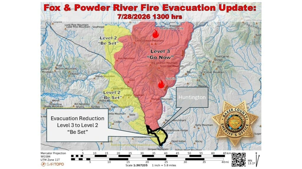
UPDATE – 7/28: Residents of the town of Huntington have been reduced from a Level 3 GO NOW Evacuation Advisory to a Level 2 BE SET notification. This change went into effect Tuesday afternoon as firefighters continue to battle the nearby Fox Fire.
Find the Baker County Sheriff’s Office advisory message below:
(From BCSO)
A reduced evacuation level (from Level 3 to Level 2) for a section of the Fox Fire has been issued. Description of the reduced level is below.
Level 2 (BE SET): South of the Burnt River, west of the Snake River, east of I-84 and north of the Baker/Malheur County Line.
This area encompasses Huntington. The City of Huntington will now be in a Level 2 (BE SET).
*****
Officials are urging motorists to use extreme caution, and slow their speeds when traveling through the Fox Fire area of I-84 near Huntington.
EMG follower Teri Henry captured the video below from I-84 near Weatherby on Monday night around 11:26 p.m.:
*****