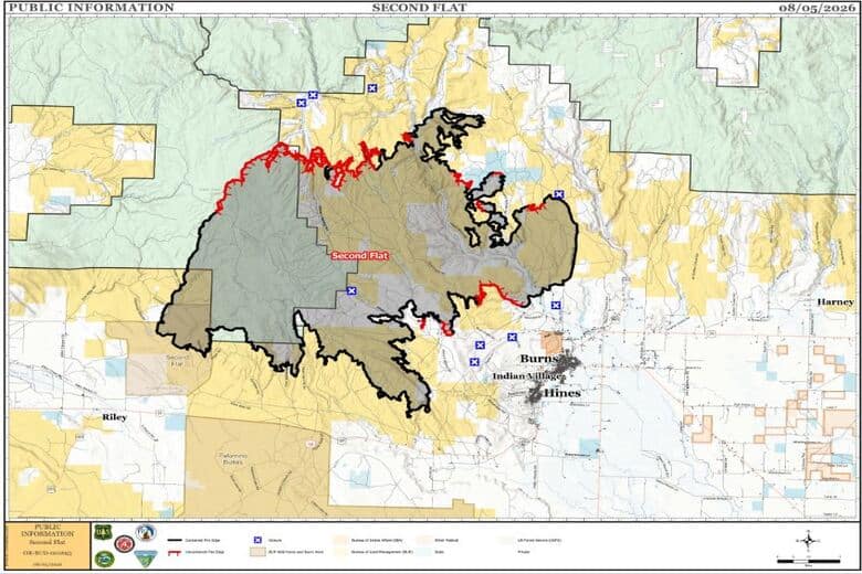
Second Flat Fire incident update as of August 5, 2026
By Mindy McKerrall on Wednesday, August 5th, 2026 in Eastern/Southeast Oregon News Eastern/Southeast Oregon Top Stories
HARNEY COUNTY-
Location: Burns Basin, Second Flat, 105,464 acres, 55% contained, Caused: Undetermined, Personnel: 470
On Tuesday, wildland firefighters continued using infrared imagery to locate and extinguish remaining hotspots within the fire area. On the perimeter, hand crews carried on surveying fire lines for containment, validating and eliminating heat signature data. Crews will continue monitoring fire activity on internal islands of unburned fuel. Overall fire progression remained at a minimum throughout the day, with crews focused on “seek and destroy” missions.
Primary areas of focus remain containment patrol along the Route 20 corridor as well as suppression efforts in the Willow Flats and Skull Creek areas. The northeastern edge of the fire is displaying no heat signatures and remains well-contained behind dozer lines. Cold trailing and mop up efforts along the northern front of the fire will proceed into the coming days as crews validate new infrared data. Additionally, all daytime objectives continue through the night as night shifts look to replicate the day’s work and move towards a morning handoff.
Going forward, fire behavior analysts anticipate conditions to stay relatively consistent. Crews remain vigilant in ensuring that any remaining hotspots are contained behind the perimeter of the fire area while continuing to mop up and cold trail along the edges of the fire line.
WEATHER
Very dry air remained in place for Tuesday as relative humidity bottomed out at 8 to 12 percent across the Second Flat Fire. The gradual warming trend continues as high pressure built back in following the dry cold front a few days ago, as high temperatures in the upper 80s to low 90s were observed across the incident. Winds were also a bit lighter than on previous days, with northwest-to northeasterly gusts around 15mph.
This trend is expected to persist into Wednesday, with single-digit humidity in the afternoon and high temperatures a few degrees warmer than Tuesday. Winds look to be a touch stronger on Wednesday as well, with gusts of 15 to 17 mph in the afternoon. Temperatures will continue to trend up into the end of the week, with slightly stronger gusts forecast for Friday and Saturday
EVACUATIONS: Evacuation orders and warnings remain in effect. For an interactive map of evacuations, visit: Genasys Protect.