Powder River Fire is 18,345 acres on Monday
By Logan Bagett on Monday, July 20th, 2026 in Northeastern Oregon News Northeastern Oregon Top Stories
RICHLAND, OR – (UPDATE 7/20 @10 a.m. from Southwest Area Incident Management Team 3)
Daily Update: July 20, 2026
Acres: 18,345 Containment: 15% Start Date: July 16, 2026
Location: Approximately 5 miles west of Richland, Oregon Cause: Undetermined
Fuels: Grass, Sage, Timber Personnel: 142
Highlights: Today command of the Powder River Fire transitioned to Southwest Area Incident Management Team 3 under the direction of Incident Commander Ken Watkins. The team brings additional overhead and firefighting resources to support ongoing fire suppression efforts. The transition is part of the interagency response process to ensure the incident has sufficient personnel, equipment, and organizational support needed as operations continue.
Operations: Firefighters continue to respond aggressively to the Powder River Fire burning approximately five miles west of Richland, Oregon. Resources have established an anchor point and are working across all sides of the fire using direct and indirect tactics where it is safe to do so. On the east side of the fire, crews will continue to reinforce and secure fire lines from Calk to Daly Creeks. On the south and west ends of the fire, dozers are working to establish containment line. Additional firefighting resources are on order to support the incident. Smokey conditions continue to hinder visibility, limiting aircraft operations. The fire is 18,345 acres and is 25% contained. Fire activity has been driven by hot, dry, and windy conditions.
Fire Restrictions: The Bureau of Land Management has issued a Notice of Temporary Restriction Order for the Vale District: https://www.blm.gov/sites/default/files/docs/2026-07/orwa-fpo-val-070626.pdf
Smoke: Smoke from the Powder River Fire and other surrounding fires, continues to affect portions of eastern Oregon and neighboring areas. Individuals, especially those with respiratory conditions, should monitor local air quality reports and limit outdoor activities when smoke concentrations are high. For more information: https://outlooks.airfire.org/outlook/ad8568e1
Weather: Cloudy, then gradually becoming mostly sunny and hot with a high near 91. North northwest winds 7 to 17 mph. An air quality alert has been issued by the National Weather Service for Baker City and the surrounding communities.
Evacuations: Evacuation orders remain in effect in portions of Baker County. The public is urged to follow directions from the Baker County Sheriff’s Office and remain aware of changing fire conditions. Fire managers understand the disruption these evacuations create and appreciate the public’s cooperation as crews work to protect communities. For more information go to state RAPTOR map at: https://arcg.is/0iKuO91.
Safety: The safety of firefighters and the public remains the highest priority. Fire managers are using both direct and indirect suppression tactics to safely contain the fire while protecting lives, homes, critical infrastructure, and natural resources. Suppression strategies are continually evaluated and adjusted as weather, terrain, and fire behavior change.
Phone Number: 541-982-5651 (7 a.m.-7 p.m.)
Email: 2026.powderriver@firenet.gov – Facebook: https://www.facebook.com/PowderRiverFire
*****
PREVIOUS:
The Baker County Sheriff’s Office has expanded evacuation orders and advisories for the Powder River Fire, citing an increased threat to residents in the area.
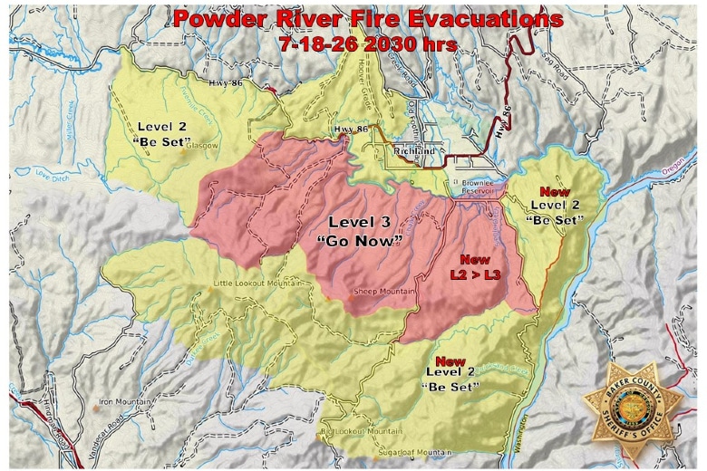
Officials issued a Level 3 “Go Now” evacuation order for territory south of the Powder River and Brownlee Reservoir, specifically east of Daly Creek Road and west of Powder River Road, stretching south to Daly Creek. Residents under a Level 3 order are instructed to leave the area immediately, as conditions pose an immediate danger to life and property.
Additionally, a Level 2 “Be Set” evacuation advisory has been expanded eastward. This zone encompasses the area south of the Powder River, east of Powder River Road, west of the Snake River, and north of Big Lookout and Sugarloaf mountains. Residents in these areas should be prepared to evacuate at a moment’s notice if conditions deteriorate.
Authorities are directing the public to monitor the state’s RAPTOR map (https://arcg.is/0iKuO91) for the most current information on zone boundaries and active fire developments. Residents are urged to follow instructions from emergency personnel and avoid the fire area to allow for safe passage of responding crews.
The Baker County Sheriff’s Office has not yet released details regarding the fire’s containment status or the number of structures potentially threatened by the latest growth.
Map courtesy Baker County Sheriff’s Office
PREVIOUS: The fast-growing Powder River Fire in Baker County was reported about a half an hour before midnight Thursday night. The fire is approximately five miles west of the town of Richland.
WildCAD updated the blaze to 2,500 acres this morning. Firefighting resources are actively engaged. We’ll provide official updates as they are released.