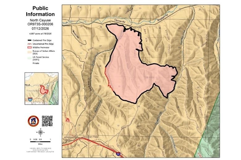
North Cayuse fire reported at 4,887 and 91% contained as of July 12 update
By Garrett Christensen on Sunday, July 12th, 2026 in Columbia Basin News More Top Stories
MISSION — (UPDATE 7/12 from the Northwest Incident Management Team) Quick Facts
Size: 4,887 acres Start Date: July 4, 2026 Location: 6 miles east of Mission, Oregon
Containment: 91% Personnel: 110
Resources Assigned: 4 crews, 1 helicopter, 3 engines, 1 dozer, 2 skidgens, 3 water tenders
CURRENT SITUATION: Yesterday firefighters on the North Cayuse Fire conducted mop-up and patrol around the perimeter of the fire. In many places, resources have cooled down hot spots up to 300 feet interior of the fire. Firefighters started the process of removing unneeded equipment from the fireline.
TODAY’S ACTIVITIES: Today firefighters will continue to patrol and strengthen control lines around the fire perimeter. Smoke will likely continue to be visible for several days as large logs smolder in interior pockets of the fire. The interior pockets of heat do not pose a threat to moving beyond established control lines. Resources will continue backhauling unneeded equipment and supplies.
WEATHER: Seasonably warm and dry conditions are expected today with typical diurnal west winds. Temperatures are forecasted to reach 82-87 degrees with minimum relative humidity around 20-25%.
EVACUATIONS: Conditions on the fire no longer warrant evacuations. Visit the Confederated Tribes of the Umatilla Indian Reservation (CTUIR) Facebook page at facebook.com/CTUIR for further information.
A Temporary Flight Restriction (TFR) of 5 miles surrounds the North Cayuse Fire. The area is required for the aircraft to safely maneuver. If You Fly, We Can’t! Please remember unauthorized drone flights can shut down aerial firefighting operations, making fires grow larger, threatening more lives, property and critical habitats.
Inciweb: inciweb.wildfire.gov/incident-information/oruma-north-cayuse-fire
Facebook: facebook.com/NorthCayuseFire/
Fire Information Line: 509-509-6869, 8 a.m. to 7 p.m.
Email: 2026.northcayuse@firenet.gov
**************
(Release from the Northwest Incident Management Team) Quick Facts
Size: 4,887 acres Start Date: July 4, 2026 Location: 6 miles east of Mission, Oregon
Containment: 66% Personnel: 393
Resources Assigned: 13 crews, 1 helicopter, 8 engines, 1 dozer, 6 water tenders
CURRENT SITUATION: The North Cayuse Fire has not experienced any growth for the last few days remaining within established control lines. Yesterday firefighters flew an aerial reconnaissance flight allowing them to view the fire from the air to assess areas where control line could be improved. Around much of the fire perimeter crews further secured existing control lines increasing the depth of mop up by cooling hot spots farther interior. In the Buckaroo Creek area, resources removed unburned brush in the upper portions of coulees to bolster the depth of secured ground between remaining interior heat pockets and control line.
TODAY’S ACTIVITIES: Firefighters will patrol and mop up around the fire perimeter. Interior pockets of heat will continue to smolder producing smoke visible from the surrounding area but not threatening to move outside control lines. A Type 1 helicopter is available to cool interior hotspots as needed. Resources are identifying suppression repair needs. Resources will begin backhauling unneeded equipment and supplies. Motorists traveling in the area may see increased fire traffic as resources demobilize from the incident.
WEATHER: A dry cold front will move through the area today bringing stronger, gustier winds in the late afternoon to early evening. Winds will gradually pick up from the west through the day peaking around 5 p.m. Temperatures are forecasted for a high of 83-88 degrees with minimum relative humidity ranging from 18-23%.
EVACUATIONS: Conditions on the fire no longer warrant evacuations. Level 1 evacuation notices issued for areas near the North Cayuse Fire by the Confederated Tribes of the Umatilla Indian Reservation (CTUIR) Emergency Management have been lifted. Visit the CTUIR Facebook page at facebook.com/CTUIR for further information.
A Temporary Flight Restriction (TFR) of 5 miles surrounds the North Cayuse Fire. The area is required for the aircraft to safely maneuver. If You Fly, We Can’t! Please remember unauthorized drone flights can shut down aerial firefighting operations, making fires grow larger, threatening more lives, property and critical habitats.
Inciweb: inciweb.wildfire.gov/incident-information/oruma-north-cayuse-fire
Facebook: facebook.com/NorthCayuseFire/
Fire Information Line: 509-509-6869, 8 a.m. to 7 p.m.
Email: 2026.northcayuse@firenet.gov