
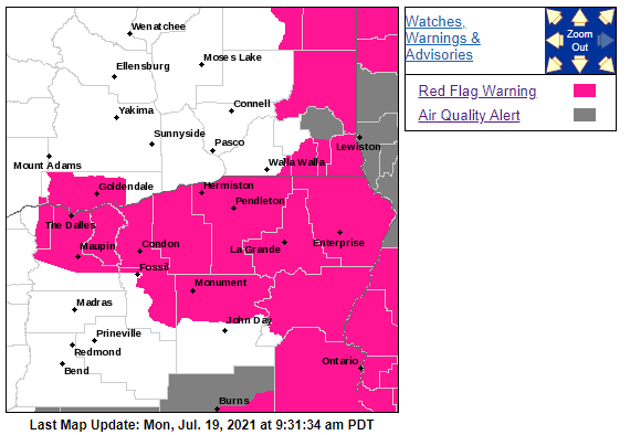
Much of Eastern Oregon under Red Flag Warning
By Logan Bagett on Monday, July 19th, 2021 in Columbia Basin News Eastern/Southeast Oregon News More Top Stories Northeastern Oregon News
The National Weather Service in Pendleton has Issued a Red Flag Warning for abundant lightning throughout much of Eastern Oregon.
Find information from the National Weather Service below:
URGENT – FIRE WEATHER MESSAGE
National Weather Service Pendleton OR
335 AM PDT Mon Jul 19 2021
…DRY AND WINDY IN THE GORGE AND EASTERN CASCADES WITH
THUNDERSTORM CHANCES IN THE EASTERN MOUNTAINS…
.Windy conditions will combine with low RH in the east slopes of the Cascades and eastern Gorge spilling into the far western Basin Today and Tuesday to promote critical fire weather conditions. There is then potential for breezy winds and low RH again Wednesday, and possibly Friday.
Meanwhile, there is potential for two rounds of isolated to widely scattered storms in the eastern mountains. Initially
Monday afternoon and overnight followed by Tuesday to Wednesday morning, the latter confined more so to the northern Blues and Wallowas.
The National Weather Service in Pendleton has issued a Red Flag Warning for abundant lightning, which is in effect from 2 PM this afternoon to 11 AM PDT Tuesday. The Fire Weather Watch is no longer in effect.
* AFFECTED AREA…Fire Weather Zone 644 Central Blue Mountains.
* THUNDERSTORMS…Isolated to widely scattered storms will be possible with a LAL of 2. Locally LAL of 3 is possible.
* Outflow Winds: Gusty outflow winds are possible near thunderstorms.
* IMPACTS…The potential for abundant lightning combined with very dry fuels may lead to increased fire starts. Breezy winds may lead to fire spread of any new or existing fires.
PRECAUTIONARY/PREPAREDNESS ACTIONS…
A Red Flag Warning means that critical fire weather conditions are either occurring now….or will shortly. A combination of strong winds…low relative humidity…and warm temperatures can contribute to extreme fire behavior.

