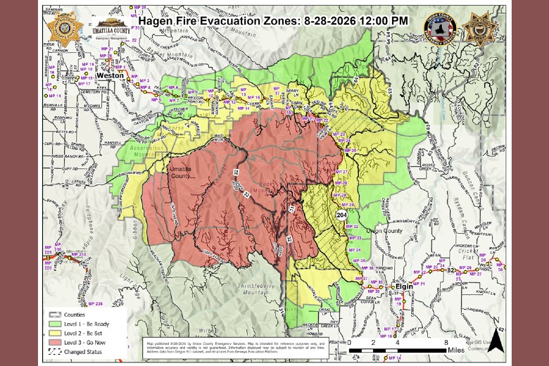
Hagen and Paradise evacuation areas are reduced
By Terry Murry on Friday, August 28th, 2026 in Columbia Basin News Columbia Basin Top Stories Northeastern Oregon News Northeastern Oregon Top Stories
From the Joint Emergency Management Command Center:
Continued progress by firefighters and improving conditions in key areas of both fires have allowed emergency officials to reduce several evacuation zones from Level 3 (GO NOW) to Level 2 (BE SET).
Effective immediately, the following evacuation levels have been REDUCED in portions of Umatilla County, Union County and the Confederated Tribes of the Umatilla Indian Reservation:
HAGEN FIRE
The Hagen Fire is currently estimated at 60,645 acres with 33% containment and 1,043 resources assigned. Crews made good progress yesterday, particularly in the Division Lima and Mike areas of the fire.
UMATILLA COUNTY AND CTUIR
REDUCED FROM LEVEL 3 TO LEVEL 2 – BE SET
Evacuation Zones:
UMC-1406015-G
UMC-1406053-B
UMC-1406053-C
UMC-1406017-A
Includes the area south of Bingham Road/County Road 900, including Bingham Springs and the Umatilla River corridor.
REDUCED FROM LEVEL 3 TO LEVEL 2 – BE SET
Evacuation Zone:
UMC-1406024-A
Includes the area north of Highway 204, east of Langdon Lake, south of NFD Road 64, and west of the Umatilla/Union County line.
UNION COUNTY
REDUCED FROM LEVEL 3 TO LEVEL 2 – BE SET
Evacuation Zones:
UCO-140624S
UCO-140612N
UCO-140612S
UCO-140610S
Includes the area east of Highway 204 surrounding the Spout Springs Ski Area, south of the Umatilla County line and north of USFS Road 3725. Also included is the area in Union County west of Highway 204 and east of Phillips Creek Road (USFS Road 3738), south of USFS Road 31. A small area of National Forest land north of the USFS boundary between Ruckle Road and Phillips Creek Road has also been reduced to Level 2.
PARADISE FIRE
The Paradise Fire is currently estimated at 9,272 acres with 13% containment and 463 resources assigned. Substantial progress was made yesterday securing the Mill Creek/Tiger Creek Road intersection and water intake structures in that area.
UMATILLA COUNTY
REDUCED FROM LEVEL 3 TO LEVEL 2 – BE SET
Evacuation Zones:
UMC-036
UMC-1406043-D
UMC-1406043-C
Includes the area east of the intersection of Mill Creek Road and Tiger Canyon Road, north to the Washington State Line, and south to include Tiger Canyon Road/NF 65, including the Intake Trail for the Mill Creek Watershed. The area is north of the Mill Creek River corridor and west of the Paradise Fire boundary.
These evacuation reductions are an encouraging sign of the progress being made on both fires. Firefighters, engines and other fire apparatus will continue working throughout these areas as crews strengthen containment features, mop up remaining heat and continue protecting homes, infrastructure and other values at risk.
Residents and travelers should continue to expect fire personnel, engines, heavy equipment and emergency vehicles operating throughout the affected areas. Drivers are asked to slow down, remain alert and give crews and equipment room to work.
All other evacuation areas not listed above remain at their current evacuation level.