Flash Flood Watch issued for much of Eastern Oregon
By Logan Bagett on Wednesday, September 10th, 2025 in Eastern/Southeast Oregon News More Top Stories
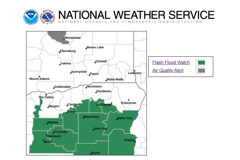
GRANT, HARNEY, MALHEUR, BAKER, UNION, AND UMATILLA COUNTIES – The National Weather Service has issued a Flash Flood Watch for a significant portion of Eastern Oregon through 11:00 p.m. tomorrow, September 11. Heavy rainfall may result in landslides and debris flows in areas of steep terrain, as well as debris flows in and near burned areas from recent wildfires. Use caution and stay posted for updates.
Find the NWS release below:
(From the National Weather Service)
Flood Watch
National Weather Service Pendleton OR
150 PM PDT Tue Sep 9 2025
.A trough will bring a chance of slow moving thunderstorms with the
potential for heavy rain to the Oregon Cascades, central Oregon and
the eastern Oregon mountains from now through Thursday evening.
ORZ503-505-506-102215-
/O.NEW.KPDT.FF.A.0005.250910T1800Z-250912T0600Z/
/00000.0.ER.000000T0000Z.000000T0000Z.000000T0000Z.OO/
Southern Blue Mountains of Oregon-John Day Basin-Ochoco-John Day
Highlands-
Including the cities of John Day, Long Creek, Ukiah, Dayville,
Spray, Brothers, North Powder, Seneca, Paulina, Prairie City,
Monument, and Mitchell
150 PM PDT Tue Sep 9 2025
…FLASH FLOOD WATCH FOR RECENT BURN SCARS IN EFFECT FROM WEDNESDAY
MORNING THROUGH THURSDAY EVENING…
* WHAT…Flash flooding and debris flows caused by excessive
rainfall is possible over recent burn scars.
* WHERE…Portions of central and northeast Oregon, including the
following areas, in central Oregon, John Day Basin and Ochoco-John
Day Highlands. In northeast Oregon, Southern Blue Mountains of
Oregon.
* WHEN…From Wednesday morning through Thursday evening.
* IMPACTS…Heavy rainfall of 1 to 1.5 inches could trigger flash
flooding of low-lying areas, and debris flows in and near numerous
recent wildfire burn scars.
* ADDITIONAL DETAILS…
– National Weather Service Meteorologists are forecasting heavy
rainfall over the burn scar, which may lead to flash flooding
and debris flows.
– http://www.weather.gov/safety/flood
PRECAUTIONARY/PREPAREDNESS ACTIONS…
You should monitor later forecasts and be prepared to take action
should Flash Flood Warnings be issued.
*****
Flood Watch
National Weather Service Boise ID
102 AM PDT Wed Sep 10 2025
ORZ061>064-102115-
/O.NEW.KBOI.FF.A.0006.250910T1800Z-250911T0600Z/
/00000.0.ER.000000T0000Z.000000T0000Z.000000T0000Z.OO/
Harney County-Baker County-Malheur County-Oregon Lower Treasure
Valley-
Including the cities of Malheur City, Ontario, Dunnean, Diamond,
Venator, Crane, Baker, Burns, Buchanan, New Princeton, and Nyssa
102 AM PDT Wed Sep 10 2025 /202 AM MDT Wed Sep 10 2025/
…FLASH FLOOD WATCH IN EFFECT FROM 11 AM PDT /NOON MDT/ THIS
MORNING THROUGH THIS EVENING…
* WHAT…Flash flooding caused by excessive rainfall is possible
especially across the Falls, Cow Valley and Durkee burn scars.
* WHERE…Portions of northeast and southeast Oregon, including the
following areas, in northeast Oregon, Baker County. In southeast
Oregon, Harney County, Malheur County and Oregon Lower Treasure
Valley.
* WHEN…From 11 AM PDT /noon MDT/ this morning through this
evening.
* IMPACTS…Heavy rainfall could trigger flash flooding or debris
flows in and near recent wildfire burn scars.
* ADDITIONAL DETAILS…
– https://www.weather.gov/safety/flood
PRECAUTIONARY/PREPAREDNESS ACTIONS…
You should monitor later forecasts and be prepared to take action
should Flash Flood Warnings be issued.