Excessive rainfall could bring possible flash flooding
By Mindy Gould on Tuesday, August 26th, 2025 in Eastern/Southeast Oregon News More Top Stories
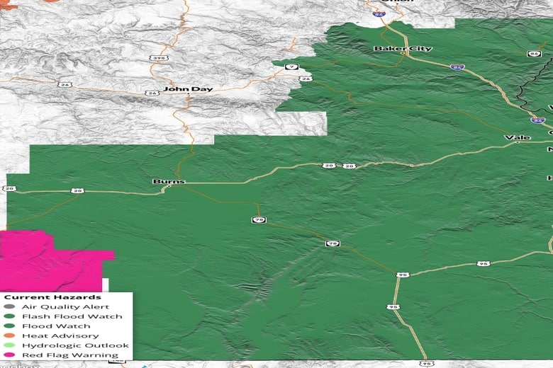
HARNEY, GRANT AND BAKER COUNTIES (Released from the National Weather Service)-A surge of deep monsoonal moisture combined with a slow-moving
upper trough will bring periods of heavy showers and thunderstorms
across the region. This airmass contains anomalously high moisture
content, supporting the potential for excessive rainfall. Flash
flooding will be possible, especially in steep terrain, narrow
canyons, and near recent burn scars where soils are less able to
absorb rainfall. The greatest risk will be Tuesday afternoon through
Wednesday evening as repeated rounds of storms move through.
FLASH FLOOD WATCH IN EFFECT FROM TUESDAY AFTERNOON THROUGH
WEDNESDAY EVENING…
* WHAT…Flash flooding caused by excessive rainfall is possible.
* WHERE…Portions of Idaho, including the following areas, Boise
Mountains, Camas Prairie, Lower Treasure Valley, Owyhee Mountains,
Southern Twin Falls County, Southwest Highlands, Upper Treasure
Valley, Upper Weiser River, West Central Mountains and Western
Magic Valley. Portions of Oregon, including the following areas,
Baker County, Harney County, Malheur County and Oregon Lower
Treasure Valley.
* WHEN…From Tuesday afternoon through Wednesday evening.
* IMPACTS…Heavy rainfall could trigger flash flooding or debris
flows in and near recent wildfire burn scars. In addition urban
street flooding is possible with the stronger storms.
* ADDITIONAL DETAILS…
– https://www.weather.gov/safety/flood
PRECAUTIONARY/PREPAREDNESS ACTIONS…
You should monitor later forecasts and be prepared to take action
should Flash Flood Warnings be issued.
Local emergency services are monitoring the situation and will issue
a public statement as conditions warrant. PLAN NOW so you will know
what to do in an emergency. Keep informed by listening to local
radio and television for statements and possible warnings. Follow
the advice of public safety officials.