Evacuation zones expanded for Salmon Fire (formerly Greenhorn Fire). Fire at 803 acres.
By Logan Bagett on Sunday, July 12th, 2026 in Eastern/Southeast Oregon News Eastern/Southeast Oregon Top Stories Northeastern Oregon News Northeastern Oregon Top Stories


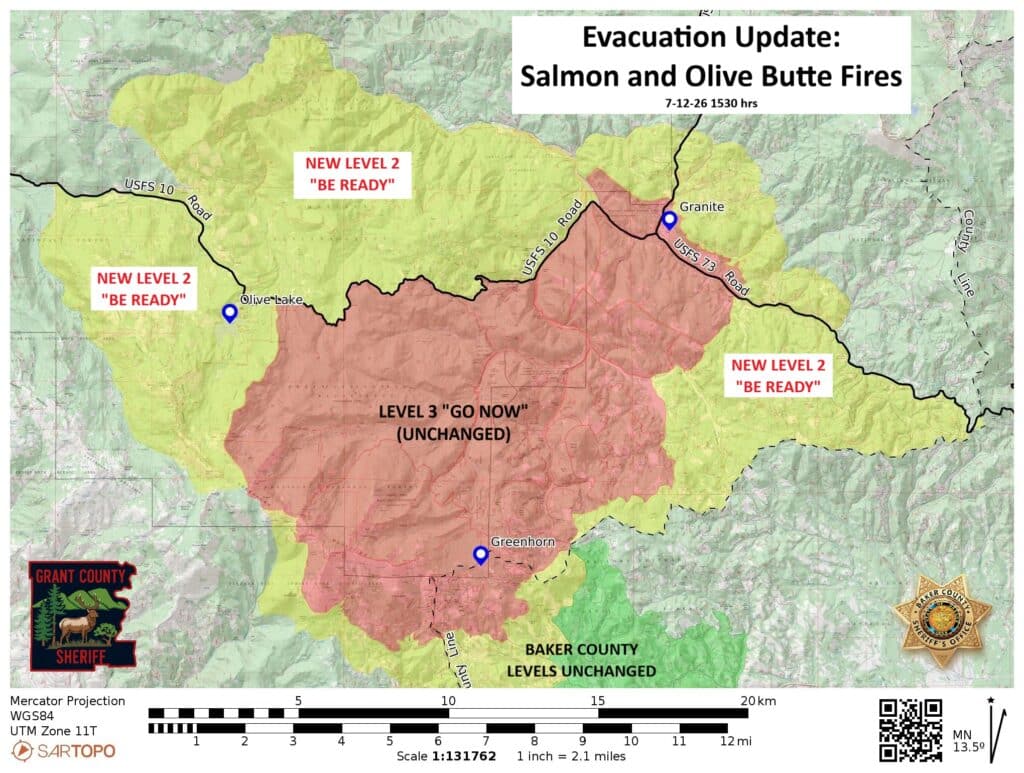
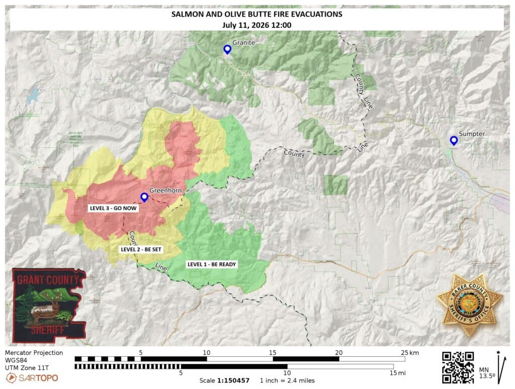
GREENHORN, OR – (UPDATE 7/12 4:00 P.M.) The evacuation zones for the Olive Butte and Salmon Fires have expanded again. Below is the newest map from the Baker County Sheriffs Office.
*******
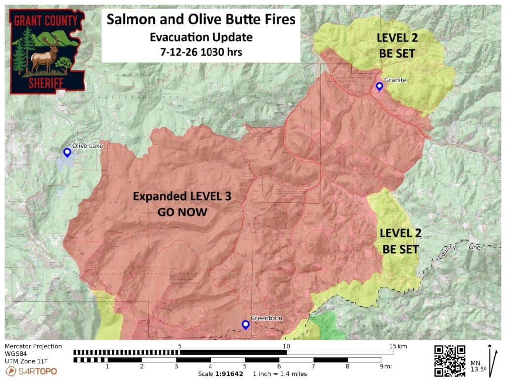
(UPDATE 7/12 11:40 A.M.) See the expanded evacuation map from the Baker County Sheriff’s Office:
*******
(UPDATE 7/12 11:25 A.M. from Northwest Team 12) Salmon Fire: Size: 803 acres | Start Date: July 8, 2026 | Cause: Lightning | Containment: 0%
Olive Butte Fire: Size: 386 acres | Start Date: July 8, 2026 | Cause: Lightning | Containment: 0%
Vinegar Hill, Cow Meadow, Caribou, Clear Creek, and Buck Gulch are all 100% contained.
Total personnel: 515 | Total Resources: 19 engines; 13 crews; 16 heavy equipment; 6 water tenders; 3 helicopters
NW Team 12 is hosting a community meeting in-person at Prairie City High School on Monday July 13 at 6 PM. The meeting will be streamed virtually on Salmon Fire OR 2026 Facebook. The community is encouraged to submit questions ahead of time to ensure team members can address them in their presentations.
Firefighters have been taking the most direct approach possible where conditions allow and made good progress in securing the Salmon Fire along a portion of the southern flank yesterday. However, heavy, highly receptive fuels combined with gusty southwest winds led to very active fire behavior with significant growth on the northeastern flanks of both fires. The Salmon Fire crossed Lightning Creek to the north and the Olive Butte Fire jumped Beaver Creek and progressed up to the ridge. Firefighters expect to be challenged by active fire behavior again today as they work today to limit fire spread towards structures and nearby communities. The Oregon State Fire Marshal (OSFM) is dispatching four structural task forces to engage in structure protection around the Granite community. The Oregon Department of Forestry and OSFM assisted with critical resources last night on both fires. Fire managers are continually reassessing conditions, adjusting tactics, and identifying multiple tactical options in a dynamic fire situation to safely and effectively suppress the fires.
Aircraft remain available to respond to priority areas on both fires. Airtankers dropping retardant, water scooper planes, and multiple helicopters have been integral in slowing the fire spread and protecting the communities of Greenhorn and Granite. Engines and handcrews continue working day and night prioritizing structure protection in these communities.
Fire crews achieved success on other small fires nearby. The Vinegar Hill Fire (approximately one acre), the Cow Meadow Fire (approximately 8 acres), the 12.5-acre Caribou Fire, Clear Creek, Buck Gulch have been secured. Unless significant changes in activity occur, this will be the final update for those fires.
Today, additional crews, equipment, and aircraft are arriving to support a range of operations from constructing fireline, implementing point protection, strengthening structure protection, and scouting for primary and alternate fireline locations. Fire managers continue evaluating roads as possible containment features.
Weather and Smoke: Mostly sunny today, with temperatures 75-80 degrees. Winds today will be SW 5-8 mph with gusts to 12 mph on ridges. For the latest information regarding smoke and air quality, check AirNow Fire and Smoke Map.
Evacuations: Residents should be prepared for changes in evacuation levels as fire conditions can rapidly change. Baker County Sheriff’s Office has issued evacuations for the Greenhorn and Granite communities. To sign up for notifications in your area, visit Grant County Everbridge or Baker County Alert.
Closures and Safety: There is a Tri-Forest Closure Order in place for the Umatilla, Malheur, and Wallowa-Whitman National Forests.The public is asked to avoid the area for everyone’s safety and to facilitate firefighting efforts. There is a Temporary Flight Restriction (TFR) over the fire area. If You Fly, We Can’t! Please remember unauthorized drone flights can shut down aerial firefighting operations, making fires grow larger, and threatening more lives, property, and critical habitats.
***************
(UPDATE 7/11, 10:00 PM from Grant County Emergency Management):
“A temporary evacuation point for those impacted by the evacuation in Granite is being established at the Sumpter Community Center, at 475 Mill St. Anyone impacted by the fire evacuations can go there and get information and support from the Red Cross.”
UPDATE (7/11 9:20 PM. From the Oregon State Fire Marshal) The Oregon State Fire Marshal is mobilizing its Green Incident Management Team and four structural task forces to the Olive Butte Fire in Grant County. Saturday evening, the Grant County Sheriff’s Office issued a Level 3 evacuation notice for the town of Granite. The evacuation notices were issued due to rapidly changing conditions.
The state fire marshal is sending three structural protection task forces from Clackamas, Lane, and Washington counties Saturday evening, with more resources arriving Sunday. These resources will work to protect life and property near the fire.
“While our wildland partners focus on the perimeter of the fire itself, our resources will work to protect homes and critical infrastructure,” Oregon State Fire Marshal Travis Medema said. “This partnership is vital as we face what has been a very busy weekend for firefighters across the state.”
Those looking for evacuation information can follow the Grant County Emergency Management page or the Oregon Department of Emergency Management’s RAPTOR Dashboard.
The Oregon State Fire Marshal Green Incident Management Team will be in unified command with Northwest Team 12.
Saturday night, Governor Tina Kotek invoked the Emergency Conflagration Act for the fire, allowing the Oregon State Fire Marshal to mobilize resources through the Oregon Fire Mutual Aid System. This is the second time the Emergency Conflagration Act has been invoked in 2026.
*****
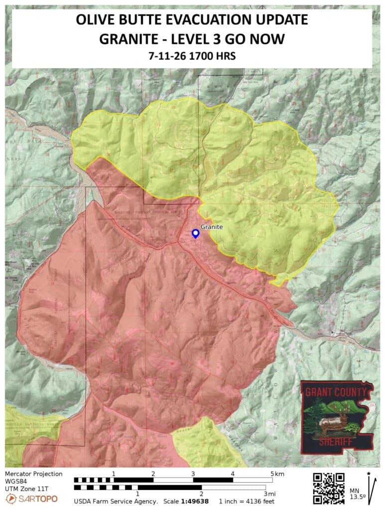
UPDATE (7/11 5:05 P.M.) The town of Granite is under a LEVEL 3 GO NOW evacuation order. Residents in the area should evacuate immediately. See the current map from the Grant County Sheriff’s Office below.
********
UPDATE (7/11 1:10 P.M) New updates have been released for the Salmon (formerly Greenhorn) and Olive Butte Fires from Northwest Team 12 and The Baker County Sheriffs Office. The new evacuation map for the complex (as provided by BCSO) is below:
The daily update on the Salmon Fire for July 12 from Northwest Team 12 is as follows:
(RELEASE FROM ORUMF SALMON)
Total personnel: 401 | Total Resources: 21 engines; 10 crews; 14 heavy equipment; 1 helicopter
Size: 533 acres | Start Date: July 8, 2026 | Cause: Lightning | Containment: 0%
Northwest Team 12 took command of the Salmon Fire and adjacent area fires yesterday at 6 AM. Firefighters and aviation resources made significant progress across the incident despite increasing fire activity on several fires.
Aircraft played a critical role throughout the day yesterday. Heavy helicopters conducted numerous water drops to slow fire spread and support crews on the ground, while helicopter rappellers rapidly responded to the remote Clear Creek and Buck Gulch Fires. After insertion by rope into steep, inaccessible terrain, the rappellers quickly contained both fires and began mop-up operations to extinguish remaining heat.
Fire activity on the Salmon Fire increased yesterday as crews observed moderate growth to the southwest and a 30-40 acre spot fire on the north side of Salmon Creek. Yesterday, fixed wing scooper planes and airtankers dropped water and retardant along the eastern flank of the fire, where firefighters had constructed dozer line at the western edge of the Greenhorn community. Firefighters also worked on improving structure protection in the Greenhorn community while crews continue working day and night to limit fire growth along the active eastern flank.
Fire crews achieved success on other small fires nearby as firefighters constructed fireline around the Vinegar Hill Fire (approximately one acre), increased containment on the Cow Meadow Fire (80% contained), and fully contained the 12.5-acre Caribou Fire. The Olive Butte Fire became more active yesterday, spreading north through heavy concentrations of dead and down timber. An abnormally low snowpack last winter has resulted in fuels drying out about a month earlier than usual, challenging fire suppression efforts.
Today, fire managers will continue evaluating opportunities for direct fireline construction wherever feasible while assessing nearby roads as potential containment features. Firefighters will focus on securing and mopping up the smaller fires, installing additional hose lays, and strengthening containment lines where conditions allow. Additional heavy equipment and hotshot crews are arriving today to help build fireline through the heavy dead and down fuels.
Weather and Smoke: Mostly sunny today, with temperatures in the upper 70s and lower 80s. Winds today will be SW 8-12 mph, gusting to 20 mph. For the latest information regarding smoke and air quality, check AirNow Fire and Smoke Map.
Evacuations: Residents should be prepared for changes in evacuation levels as fire conditions can rapidly change. Baker County Sheriff’s Office has issued a level 3 evacuation for Greenhorn area that is still in effect. To sign up for notifications in your area, visit Grant County Everbridge or Baker County Alert.
Closures and Safety: There is a Tri-Forest Closure Order in place for the Umatilla, Malheur, and Wallowa-Whitman National Forests.The public is asked to avoid the area for everyone’s safety and to facilitate firefighting efforts. There is a Temporary Flight Restriction (TFR) over the fire area. If You Fly, We Can’t! Please remember unauthorized drone flights can shut down aerial firefighting operations, making fires grow larger, and threatening more lives, property, and critical habitats.
***********
UPDATE (7/10 12:50 p.m. from Umatilla National Forest)
Northwest Team 12 was briefed yesterday and took command of the Salmon Fire along with Caribou Fire, Cow Meadow Fire, Olive Butte Fire, Vinegar Hill Fire, Clear Creek Fire and Buck Gulch Fires early this morning.
The team is setting up an InciWeb page for the Salmon Fire and a Facebook can be found at https://www.facebook.com/SalmonFireOR2026/ and will have information posted this afternoon.
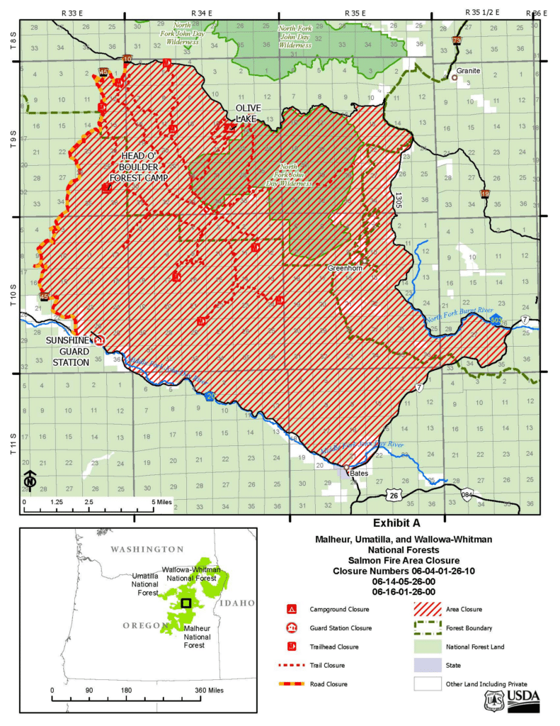
Forest officials have a temporary area closure for public safety and to facilitate firefighting operations in the area surrounding. The orders can be found on any of the three forests websites.
Traffic on State Highway 7, County Road 20, County Road 503, National Forest Service (NFS) Roads 10, 13, and 1305 around closure area remain open to through traffic and are not impacted by this closure. NFS Road 45 is closed for public access.
The Salmon Fire is still estimated at 1,000 acres and crews are continuing to improve the line to protect the community of Greenhorn.
Weather: Weather is expected to be similar to what has happened since this incident started with winds blowing out of the northwest at 8 to 12 mph with gusts up to 20 mph. The combination of predicted winds, low relative humidities and fuel loading in the area is a concern for firefighters.
A Temporary Flight Restriction (TFR) of 7 nautical miles centered around Vinegar Peak surrounds the Salmon Fire. The area is required for aircraft to safely maneuver.
If You Fly, We Can’t! Please remember unauthorized drone flights can shut down aerial firefighting operations, making fires grow larger, threatening more lives, property, and critical habitats.
A level 3 evacuation notice for the Greenhorn area is still in effect by Baker County Sheriff’s Office.
The public is asked to avoid the area for everyone’s safety and to facilitate the firefighting efforts.
Officials want to remind everyone that the current fire danger rating is at MODERATE and as of this morning Public Use Restricts Phase A are in effect for Umatilla National Forest.
For the latest information regarding smoke and air quality see https://fire.airnow.gov/
For more information regarding Restrictions, please contact:
Umatilla National Forest:
Information Hotline: Toll-Free (877) 958-9663
www.facebook.com/UmatillaNF
X: @UmatillaNF
Additional information about the Umatilla National Forest is available at: http://www.fs.usda.gov/umatilla
*****
UPDATE (7/9/26 from the Baker County Sheriff’s Office)
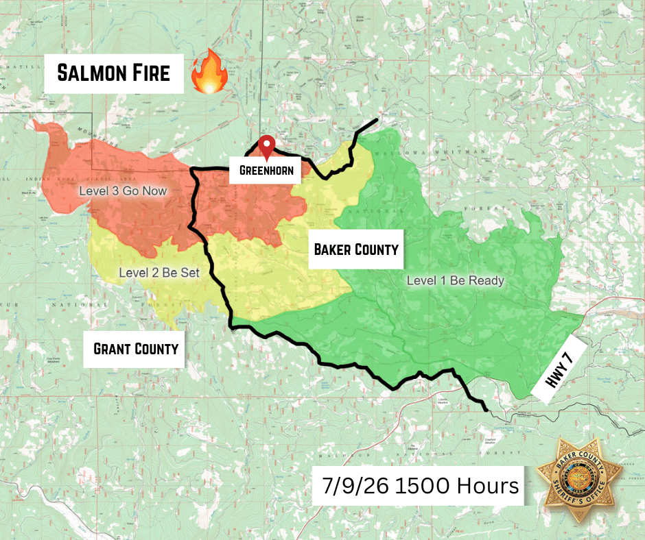
A new and expanded evacuation map has been issued for the Salmon Fire (formerly the Greenhorn Fire) by the Baker County Sheriff’s Office. See the new map below:
*****
UPDATE (7/9/26 from the Umatilla National Forest):
Yesterday afternoon the Salmon and Greenhorn Fires merged into one fire and will now be referred to as the Salmon Fire. Officials have ordered a Complex Incident Management Team which will transition with the current Incident Management Team tomorrow morning at 6 am. They will be managing the Salmon Fire along with the Caribou Fire, Cow Meadow Fire, Olive Butte Fire, and Vinegar Hill Fire.
Forest officials will soon issue a temporary area closure around the fires for public safety and to facilitate firefighting operations.
The Salmon Fire is now estimated at 1,000 acres, and crews are working on improving the line to protect the community of Greenhorn.
Weather: Weather is expected to be similar to what happened yesterday with winds that are predicted to increase in the afternoon blowing out of the northwest at 8 to 15 mph with gusts up to 22 mph after 3:00 pm. The combination of predicted winds, low relative humidities and fuel loading in the area is a concern for firefighters.
A Temporary Flight Restriction (TFR) of 7 nautical miles centered around Vinegar Peak surrounds the Salmon Fire. The area is required for the aircraft to safely maneuver.
If You Fly, We Can’t! Please remember unauthorized drone flights can shut down aerial firefighting operations, making fires grow larger, threatening more lives, property, and critical habitats.
A level 3 evacuation notice for the Greenhorn area was issued by Baker County and is still in effect.
The public is asked to avoid the area for everyone’s safety and to facilitate firefighting efforts.
Officials want to remind everyone that the current fire danger rating is at MODERATE for Umatilla National Forest.
For the latest information regarding smoke and air quality see https://fire.airnow.gov/.
*****
UPDATE (7/9/26 @ 9:30AM):
The Oregon State Fire Marshal has mobilized two structural task forces through Immediate Response to the community of Greenhorn. The Baker County Sheriff’s Office has Level 3 evacuations in place for the Greenhorn Fire, updated Thursday morning to 108.1 acres. The nearby Salmon Fire was updated at just under 230 acres.
The public is asked to avoid the area for everyone’s safety and to facilitate the firefighting efforts.
Yesterday morning, the Baker Fire Defense Board Chief and county commissioners requested assistance to help protect homes and critical infrastructure. The Fire Marshal is sending two task forces from Lane and Yamhill counties, and a division supervisor from Portland Fire & Rescue.
*****
UPDATE (7/8/26 2:40PM):
(From the Umatilla National Forest)
Multiple thunderstorms passed over the Greenhorn area last evening igniting several fires on the southeastern corner of the Umatilla National Forest and on the Malheur National Forest. Two of these fires are currently burning near Greenhorn.
The Salmon Fire, estimated at 10 acres, is burning half a mile to the northwest of Greenhorn in heavy dead and down fuels and subalpine fir. This is on the boundary of the North Fork John Day Wilderness. Last night’s observed fire behavior included torching of small groups of trees and 2-5 ft flame lengths through the ground fuels. Crews are on scene and working to bring heavy equipment to the fireline where feasible. Aircraft including heavy helicopters and air attack have been ordered.
The Greenhorn Fire, estimated at 10 acres, is also burning in dead and down fuels with subalpine fir. This fire is about 1.5 miles to the west of Greenhorn. Active fire behavior was seen until 3:00 am with torching and 2-5 ft flame lengths. Crews are working this morning to gain access with heavy equipment.
Winds are predicted to increase this afternoon blowing out of the northwest at 8 to 15 mph with gusts up to 22 mph after 3:00 pm. The combination of predicted winds, low relative humidities and fuel loading in the area is a concern for firefighters.
A level 3 evacuation notice for the Greenhorn area was issued by Baker County and is currently in effect.
The public is asked to avoid the area for everyone’s safety and to facilitate the firefighting efforts.
Officials want to remind everyone that the current fire danger rating is at MODERATE for Umatilla National Forest.
For the latest information regarding smoke and air quality see https://fire.airnow.gov/
For more information regarding Restrictions, please contact:
Umatilla National Forest:
Information Hotline: Toll-Free (877) 958-9663
www.facebook.com/UmatillaNF
X: @UmatillaNF
The latest fire information will be posted on the Blue Mountains Fire Information Blog. To receive updates on fires in the Blue Mountains, follow our blog at http://bluemountainfireinfo.blogspot.com/.
Additional information about the Umatilla National Forest is available at: https://www.fs.usda.gov/umatilla
*****
UPDATE (7/8/26 10:20AM):
(From the Baker County Sheriff’s Office)
Evacuation levels for Greenhorn remain at Level 3 (GO NOW). No new orders have been issued. Additional structure protection crews have been requested.
*****
PREVIOUS (7/7/2026): (From Baker County Sheriff’s Office)
A fire has been reported near Greenhorn.
Baker County Sheriff’s Office has issued the following evacuations:
Level 3 (GO NOW): Greenhorn
Baker County Sheriff’s Office deputies and search and rescue members are in the area to conduct door-to-door notifications.
Fire resources are on scene to provide structure protection.