Evacuation levels updated 7/26 on Umatilla County’s Hagen Fire
By Logan Bagett on Sunday, July 26th, 2026 in Columbia Basin News More Top Stories
UMATILLA COUNTY – (UPDATE 7/26 from the Umatilla County Sheriff’s Office)
FOR IMMEDIATE RELEASE
EVACUATION LEVELS UPDATED ON HAGEN FIRE (NW IM TEAM 7)
07-26-2026 @ 10:30 a.m
A Joint Emergency Operation Center including Umatilla County Sheriff’s Office, Umatilla County Emergency Management, Union County Sheriff’s Office, Union County Emergency Management and Confederated Tribes of the Umatilla Indian Reservation (CTUIR) remain actively engaged with the Northwest Incident Management Team 7 for Hagen Fire.
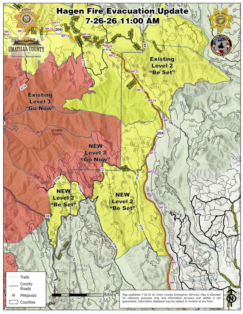
The following evacuation levels have been increased on the Hagen Fire effective immediately:
LEVEL 3 (GO NOW)
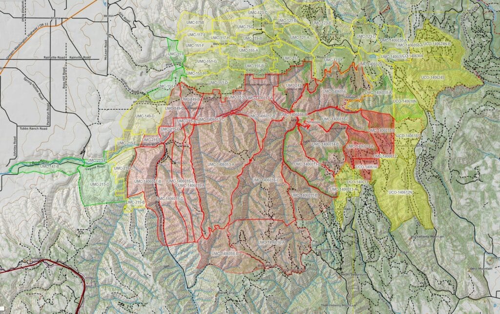
Evacuation Zones:
UMC -1406018-B
UMC – 1406014-A
UCO- 140614
LEVEL 3 areas in Umatilla County are South of the North Fork Umatilla River, West of the Umatilla/Union County Border, North of the Umatilla/ Union County Border.
LEVEL 3 areas in Union County include the area northeast of the USFS 3150 Road and northwest of the USFS 31 Road up to the county line with Umatilla County. All of this LEVEL 3 area is currently under USFS administrative closure for public and firefighter safety.
Level 2 (BE SET)
Evacuation Zones:
UMC-1406013-A
UCO- 140613
UCO- 140612-N
LEVEL 2 increases in Umatilla County include South of Forest Road USFS 3150, West of the Union County/ Umatilla Border, Including FS road 228, 229 and North of Roest Road 3145
LEVEL 2 increases in Union County The area northwest of the USFS 31 Road and southwest of the USFS 3150 Road up to the county line with Umatilla County, and also the area of Ninemile and Middle Ridges south of the USFS 31 Road between the USFS 3738/Phillips Creek Road and Highway 204 (north of the USFS 3148 – 3738 intersection and milepost 32.5 on Highway 204). All of this LEVEL 2 area is currently under USFS administrative closure for public and firefighter safety.
We continue to instruct residents in all the areas to take extra precautions. While every effort is being made to provide timely updates on evacuation levels and fire behavior, local terrain presents significant communication and access challenges.
Due to the remote nature of these affected areas and the predicted weather conditions, residents must remain extremely vigilant and proactively monitor surrounding fire activity. Fire conditions can change rapidly and unpredictably. Do not wait for an official evacuation order if you feel unsafe or see immediate danger.
Additionally the public is warned that there is a heavy presence of fire apparatus, emergency response vehicles, fire crews and law enforcement operating throughout the area. Members of the public are strictly urged to remain clear, unless travel is absolutely necessary. Unnecessary traffic can interfere with emergency personnel and fire crews and create safety risks to both the public and critical operations.
Continue to follow official fire updates at Paradise, Hagen and Horse Ridge Fire Information.
The most current Evacuation Levels and information for Umatilla County can be found on our webpage Emergency Advisories: https://umatillacounty.net/…/emerg…/emergency-advisories
Current Evacuation Map:
https://protect.genasys.com/…/45.689029%2C-118.249671…
RAPTOR (this link geographically opens on the full extent of the Hagen Fire in both counties): https://arcg.is/0SjKLG1
Union County Emergency Services: https://unioncountyor.gov/emergency-services/es-current-alerts/
Sign-up for emergency alerts: www.oralert.gov
*****
A Joint Emergency Operation Center including Umatilla County Sheriff’s Office and Umatilla County Emergency Management, Union County Sheriff’s Office and Confederated Tribes of the Umatilla Indian Reservation (CTUIR) remain actively engaged with the Northwest Incident Management Team 7 for Hagen Fire.
The following areas on the Hagen Fire have been increased to a LEVEL 3 effective immediately:
LEVEL 3 – GO NOW
Evacuation Zones:
UMC -1406011-B
UMC -1406016-A
UMC -1406008-B
This extends already existing LEVEL 3 zones into the Umatilla National Forest, now east from the FS Road 32 / 320 spur, south to include Black Mountain and including Little Goodman Ridge, then east over to the intersection of FS Road 3128 and FS Road 3130, north up the FS Road 3130.
Umatilla County Sheriff’s Office and Umatilla County Search and Rescue members are in evacuation areas around the fire, ready to respond immediately to changing conditions.
We continue to instruct residents in all the areas to take extra precautions. While every effort is being made to provide timely updates on evacuation levels and fire behavior, local terrain presents significant communication and access challenges.
With the current and forecasted weather conditions, including today’s Red Flag Warning from the National Weather Service, we anticipate critical fire conditions. Strong winds, low humidity, and warm temperatures may contribute to extreme fire behavior.
Due to the remote nature of these affected areas and the predicted weather conditions, residents must remain extremely vigilant and proactively monitor surrounding fire activity. Fire conditions can change rapidly and unpredictably. Do not wait for an official evacuation order if you feel unsafe or see immediate danger.
Additionally the public is warned that there is a heavy presence of fire apparatus, emergency response vehicles, fire crews and law enforcement operating throughout the area. Members of the public are strictly urged to remain clear, unless travel is absolutely necessary. Unnecessary traffic can interfere with emergency personnel and fire crews and create safety risks to both the public and critical operations.
(Photos are from Friday 07/24/2026 while Umatilla County Sheriff’s Office patrolled along Bingham Rd up to the Umatilla North Forks Camp Ground area)