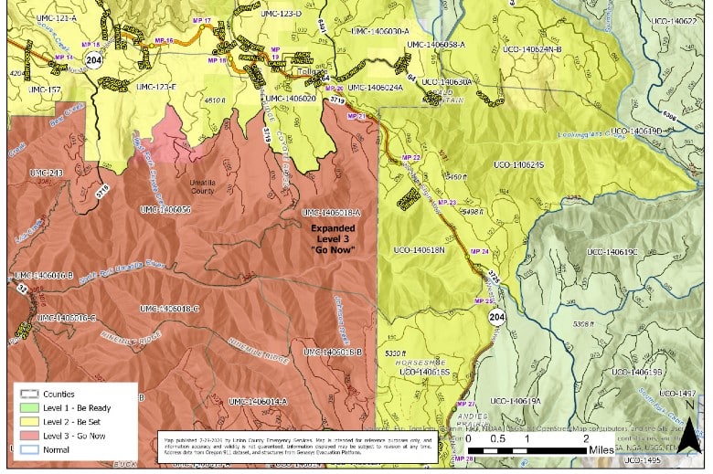
Evacuation levels increase in Umatilla County for Hagen Fire
By Terry Murry on Wednesday, July 29th, 2026 in Columbia Basin News More Top Stories
UMATILLA & UNION COUNTIES – The Emergency Operation Center has upgraded an area impacted by the Hagen Fire from be ready to GO NOW. That includes the area south of the National Forest 3719 Road east to the Umatilla County line. It is categorized as UMC-1406018-A.
The Emergency Operation Center is being run by Umatilla County Emergency Management, Umatilla County Sheriff’s Office, Union County Emergency Management, Union County Sheriff’s Office, and the Confederated Tribes of the Umatilla Indian Reservation.
The center is working closely with the Northwest Incident Management Team 7 on the Hagen Fire. This morning’s report on three fires from that team is:
Firefighters Advance in Containing Fires
Update: Moderate weather has allowed firefighters to make significant progress containing the three fires. The smoke shading from other Oregon fires slowed activity on the fires and is expected to continue.
There are 939 people working out of bases in Walla Walla, Elgin and Athena. The new spike camp in Elgin is supporting over three hundred firefighters to advance fire lines being built to the south and east of the Hagen Fire.
Northwest Team 7 is working to contain these fires in collaboration with the Umatilla and Walla Walla County Sheriff’s offices, City of Walla Walla, state agencies, and the Confederated Tribes of the Umatilla Indian Reservation. These agencies are collaborating to protect human safety, structures and communities, safeguard the Walla Walla municipal water supply, railroad corridors, private timber and range lands, and recreation opportunities.
The Paradise Fire (763 acres) is about 10 miles southeast of Walla Walla. Firefighters continue to put in direct fire line where possible as the fire showed minimal growth yesterday. Containment around Paradise fire includes both direct and indirect line as extreme terrain and difficult access permits. As the Paradise Fire is entirely within the municipal watershed for the City of Walla Walla it requires very careful suppression activity to preserve the integrity of the watershed.
The Hagen Fire (31,862 acres) is about 9 miles southwest of Tollgate, Oregon is about 12 miles northwest of Elgin, Oregon and is now 3% contained. The fire is expanding to the south and east, with only moderate spread to the west as the fire backs down a ridgeline. Bingham Road remains as the northern boundary of the fire. Progress is being made to tie in the fire lines to the south, east, and west to completely encircle the fire. A burnout operation to improve fire line and secure the west side of the Hagen Fire along Rattlesnake Ridge is planned to take place today.
The Horse Ridge Fire (838 acres) about 5 miles northeast of Meacham, Oregon showed minimal fire behavior and is 76% contained. Under the monitoring, mopping up, and patrols by firefighters the fire has remained within the fire line. Firefighters will work to ensure the containment percentage increases.
Evacuation Levels: The Umatilla County Sheriff reminds the public that due to the remote nature of these affected areas, residents must remain extremely vigilant and proactively monitor surrounding fire activity. Fire conditions can change rapidly. Evacuation levels have been elevated in areas of Umatilla County, Union County and the Confederated Tribes of the Umatilla Indian Reservation. See the advisories at https://www.umatillacounty.net/departments/sheriffs-office/emergency-management/emergency-advisories. Follow the Sheriff’s Office on Facebook for evacuation updates: https://www.facebook.com/UmatillaCountySheriff
Fire and Fuels Advisory: The Northwest Coordination Center’s Predictive Services has issued an advisory https://gacc.nifc.gov/nwcc/content/pdfs/Fuels_and_Fire_Behavior_Advisory_PNW_0728.pdf. This winter’s record low snowpack in the Northwest, along with recent drought conditions, has led to live and dead fuels curing significantly earlier than usual. Fire activity is already reflecting patterns normally seen much later in the fire season. Alignment in the fire environment is producing extreme fire behavior.
Weather and Fire Behavior: Unexpectedly strong humidity recovery overnight and in the morning hours should help to moderate fire growth for the morning with humidity dropping in the afternoon. There is still the possibility for spotting up to a quarter mile. The average humidity will drop throughout the week and is expected to increase fire behavior and intensity starting tomorrow. Heavy smoke from other fires will continue to limit visibility in the morning but may clear but the afternoon.
Smoke Outlook: For current smoke reports visit https://fire.airnow.gov. For detailed northeast Oregon air reports, visit https://outlooks.wildlandfiresmoke.net/outlook/61e48530. For southeast Washington, visit https://outlooks.wildlandfiresmoke.net/outlook/bb27fabc.
Fire Restrictions: The Umatilla National Forest has issued public use restrictions https://www.fs.usda.gov/r06/umatilla/alerts/phase-c-public-use-restrictions for smoking, off-road travel, and chainsaw use across the entire national forest.
Umatilla National Forest Closures: Forest officials have issued the following Forest Closure Order, https://www.fs.usda.gov/sites/nfs/files/r06/umatilla/publication/alerts/06-14-06-26-09_Hagen-HorseRidgeFire_FullOrder.pdf for public safety and to facilitate firefighting operations. Areas included in the closure include Corporation Guard Station and Trailhead, North Fork Umatilla Trailhead, Umatilla Fork Day-Use Area and Campground, Buck Creek Cabin, and Buck Creek Trailhead.
Air Space Restrictions: Temporary Flight Restrictions are in place over the wildfires. If you fly, we can’t. Every time a drone is spotted near the fire all aircraft are grounded until we can be sure the drone is clear of this area. http://knowbeforeyoufly.org