Containment increases on both the Paradise and Hagen fires – 9-2 Update
By Terry Murry on Wednesday, September 2nd, 2026 in Columbia Basin News Columbia Basin Top Stories Northeastern Oregon News Northeastern Oregon Top Stories
| PUBLIC SAFETY: Evacuation levels change quickly. Please check official sources often. | |||
| Fire | Size* | Containment | Personnel |
| Hagen | 61,305 acres | 53% | 859 |
| Paradise | 9,593 acres | 22% | 373 |
*Our reported acreage comes from the ICS-209, the official source used across all incident updates and posted on InciWeb to maintain consistency. Infrared mapping flights often occur overnight and can produce updated perimeter data that appears sooner on platforms like Watch Duty. Those numbers can sometimes be useful for situational awareness, but we publish only the acreage that has been verified for accuracy.
Southern Area Team 3 will transfer command of the Paradise and Hagen Fires to Northwest Team 8 tomorrow at 6 a.m. Team 3 Incident Commander Bart Kicklighter thanks the local communities for their warm hospitality in welcoming all team members and firefighters to the area.
“I’m proud of the progress the firefighters and crews have made on both the Hagen and Paradise Fires while our team has been in Walla Walla and Elgin,” said Kicklighter. “I know that we are leaving both fires in excellent hands under the leadership of Team 8’s Incident Commander Adam Veale and his capable team.”
- Hunting season is underway. Hunters and visitors are asked to comply with all forest closures and remain alert as firefighters and equipment may be working outside the immediate fire area.
- Slow down and stay alert on the roads. Give fire vehicles and equipment plenty of space to help keep firefighters, equipment operators, and the community safe.
CURRENT CONDITIONS AND PLANNED ACTIVITIES
Hagen Fire
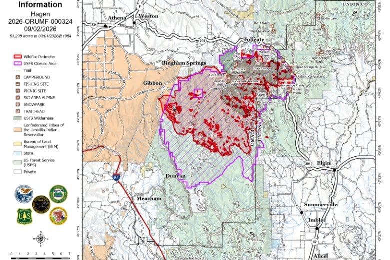
The increase in acreage continues to reflect fire spread within the existing footprint. Wednesday’s work includes continued mop up, with aircraft supporting hotspot detection. Crews will also be removing water handling equipment including portable pumps and hose lays ahead of the forecasted rainfall.
Paradise Fire
Firefighters continue to reinforce control lines and mop up remaining hotspots. Priority areas include the Mill Creek drainage and around the water intake system, Forest Service Road 65, and other natural and constructed barriers that have helped hold the fire’s spread.
WEATHER AND FIRE BEHAVIOR
A cooler, wetter pattern is expected Wednesday morning and will likely hold through the rest of the week. Temperatures will drop to the low 60s, with potential for widespread rain and thunderstorms from Wednesday morning and throughout the day. Lightning, brief heavy downpours and strong outflow winds are possible. The weather is expected to moderate fire behavior. Heavy fuels will continue to smolder causing smoke. Gusty winds and lightning from the storms could spark new local activity. However firefighting crews are ready to respond quickly to any new fires that may start.
Above map of the Paradise Fire, map below of the Hagen Fire from Southern Area 3 Incident Command Team