Anthony fire reported at over 1,400 acres. Evacuations remain in place.
By Garrett Christensen on Friday, July 10th, 2026 in Northeastern Oregon News Northeastern Oregon Top Stories
ANTHONY LAKES, OR – BAKER COUNTY – (UPDATE 7/12 11: A.M. From the Anthony Fire information team) Quick Facts
Size: 1,472 acres Start Date: July 8, 2026 Location: 34 miles north of Baker City, OR
Containment: 0% Personnel: 276 Cause: Natural – Lightning
Resources Assigned: 8 crews, 3 helicopters, 3 engines, 4 water tenders, 11 heavy equipment
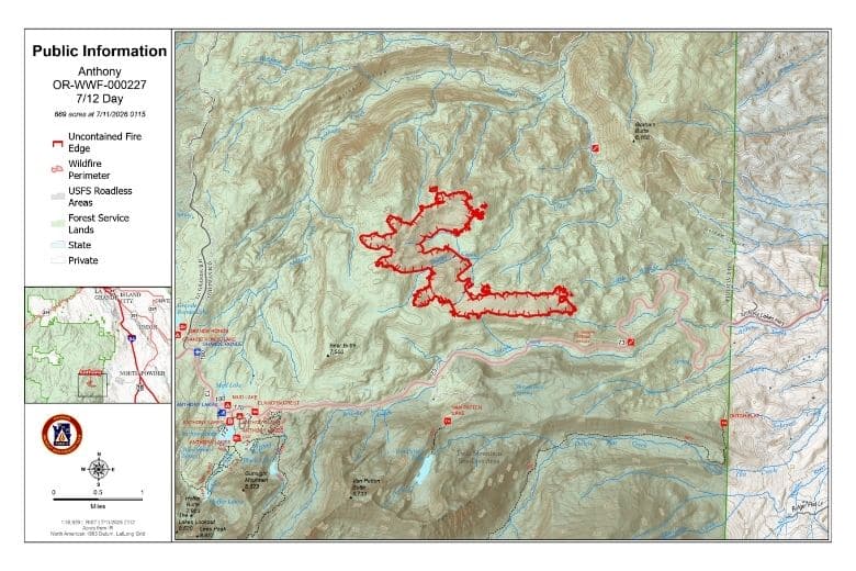
CURRENT SITUATION: Yesterday, fire activity increased on the Anthony Fire with higher winds and low humidity. Fire behavior included tree torching with flame lengths upwards of 100 feet. The fire grew towards the north and east through a combination of surface burning, torching, short crown runs and spotting. Due to significant increase in fire intensity and spread rates, firefighters dropped back to pre-identified indirect control lines along Forest Service Roads 73, 7312 and 43. Crews continued to perform structure protection in the Floodwater Flats area. Firefighting aircraft supported firefighters working on the ground. In addition to increased smoke from the Anthony Fire, smoke from the neighboring Salmon and Olive Butte Fires was clearly visible and impacted local communities.
TODAY’S ACTIVITIES: Northwest Complex Incident Management Team 3 took command of the Anthony Fire at 7 a.m. Today, resources will continue to construct indirect lines and look for opportunities to go direct with the overall intent to keep the fire as small as possible. Additional resources are on order or being reassigned from other incidents. On the south side of the fire, firefighters will strengthen control lines along Forest Service Road 73. Resources on the east side of the fire will bolster holding features along Forest Service Road 7312. On the west side of the fire heavy equipment is constructing contingency line along Forest Service Road 43. Firefighters are scouting for options to construct direct control line close to the fire’s edge as well as additional contingency lines that could be used if fire activity increases and poses safety concerns for resources constructing direct control line. Aircraft is ready to support ground operations as needed. Structure protection will continue in the Floodwater Flats and Anthony Lakes.
WEATHER: Seasonably warm and dry conditions are expected today with light slope driven winds in most areas. Exposed areas will see a generally light, southwest wind. Temperatures are forecasted to reach 68-73 degrees with relative humidity dropping to 25-30%.
EVACUATIONS: Level 1, 2 and 3 evacuations are currently in place for the Anthony Fire. To view the current evacuation details, please visit the Baker County Sheriff’s Office Facebook page at facebook.com/people/Baker-County-Sheriffs-Office/100064434892363/.
CLOSURES: The Wallowa-Whitman National Forest has implemented a temporary emergency closure around the vicinity of the Anthony Fire. For additional details visit fs.usda.gov/r06/wallowa-whitman/alerts/anthony-fire-area-closure.
InciWeb: inciweb.wildfire.gov/incident-information/orwwf-anthony-fire
Facebook: facebook.com/WallowaWhitmanNF/
Closure: fs.usda.gov/r06/wallowa-whitman/alerts/anthony-fire-area-closure
Fire Information Line: 509-509-6869, 8 a.m. to 8 p.m.
Email: 2026.anthony@firenet.gov
***********
(UPDATE 7/12 9:45 A.M.) According to a morning update from incident commander James Osborn (seen above), the Anthony Fire has continued to see northern and easter growth following the passing of a dry cold front through the area. Crews are currently focusing on holding the fire along roads 73, 43, and 73-12.
According to the National Interagency Fire Center, the Anthony Fire is approximately 750 acres in size of the morning of July 12. As written by the NIFC:
“Firefighting crews are working on primary control lines and are supported with air operations. This includes dozer and handline construction. Work is also focusing on protecting structures. At this time, the fire is not impacting the Anthony Lakes Ski Resort.”
**********
UPDATE (7/10 12:25 p.m.)
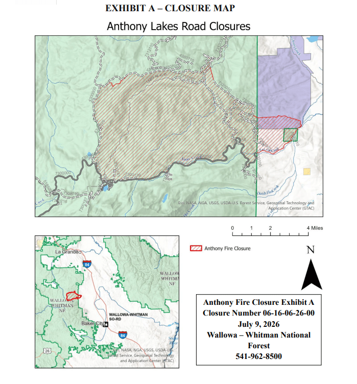
The Wallowa-Whitman National Forest has issued a closure order for areas surrounding the Anthony Fire. Read the closure description, accompanied by a map, below:
(Anthony Fire Closure Order from the Wallowa-Whitman National Forest)
Pursuant to 16 USC§ 551 and 36 CFR 261.50 (a) and (b), the following acts are prohibited on the Whitman Ranger District of the Wallowa-Whitman National Forest as shown on the attached map (Exhibit A). These prohibitions will become effective July 9, 2025, and will remain in effect until December 31, 2025, or until rescinded.
PROHIBITION:
1. Being on a road. (36 CFR§ 261.54(e))
2. Being on a trail. (36 CFR§ 261.55(a))
3. Entering into or being upon an area closed for the protection of public health and safety. 36 CFR§ 261.53(e).
These prohibitions are in addition to the general prohibitions in 36 CFR Part 261, Subpart A.
CLOSURE DESCRIPTION:
The closure applies to the NFS areas, roads, campgrounds, and trails and trailheads described below and as depicted on the Map (Exhibit A).
• The Forest Service Road (FSR) 73 road from the crossing of the North Powder River to the intersection of the FSR 43 road.
• The FSR 43 road is closed starting at the FSR 73 intersection to the intersection of FSR 4380.
• FSR 4380 in the intersection of FSR 7312 is closed.
• FSR 7312 from the bridge at Anthony Creek to FSR 7300 is closed.
All portions of the Wallowa-Whitman National Forest between FSR 4380 in the intersection of FSR 7312 cross country to the ridgeline of Gorham Butte to FSR 7320050, continuing along the FSR 7320 to the intersection of the FSR 7302 east along the ridgeline to private road 6062 continuing to Anthony Lakes Highway.
EXCEPTIONS:
Pursuant to 36 CFR, Sec. 261.50 (e), the following persons are exempt from this order:
1. Persons with Forest Service Permit No. FS-7700-48 (Permit for Use of Roads, Trails, or Areas Restricted by Regulation or Order) specifically authorizing the otherwise prohibited act or omission.
2. Any Federal, State or local law enforcement officer, or member of an organized rescue or firefighting force in the performance of an official duty.
These prohibitions are in addition to the general prohibitions in 36 CFR Part 261, Subpart A.
Violation of these prohibitions is punishable by a fine of not more than $5000 for an individual or $10,000 for an organization, or imprisonment for not more than 6 months, or both. (16 U.S.C. 551 and 18 U.S.C. 3559 and 3571)
Signed at Baker City, Oregon, this 9rd of July 2026.
STATEMENT OF NEED:
This closure is necessary to provide forest visitors protection from the current hazardous conditions associated with an active fire situation as well as to allow for the safety and access for the fire personnel.
ENFORCEMENT PROCEDURES:
Enforcement will be conducted by FPOs, LEOs and SAs. Discretion will be used in the first couple of days after enacting the order and the preferred method of compliance will be a warning since the goal is to clear the area and protect the public.
POSTING:
Posting shall be done by the forest staff or fire personnel assigned to the fire. Posting should be made at all major access points to the area.
*****
(UPDATE 7/9/26 1:30 p.m. from IMT 3):
Northeast Oregon Incident Management Team (IMT) 3 has officially assumed command of the Anthony Fire, which began on July 8, 2026, approximately 2 miles northeast of Anthony Lakes Ski Resort. The fire currently affects more than 300 acres.
Incident Overview
Start Date: July 8, 2026
Location: Approximately 2 miles northeast of Anthony Ski Resort
Size: More than 300 acres
Cause: Lightning
Evacuations: Evacuation orders are in place. Visit the Baker County Sheriff’s Facebook page for official notices: https://www.facebook.com/people/Baker-County-Sheriffs-Office/100064434892363/
Closures: Area closures may be forthcoming. Visit https://www.fs.usda.gov/r06/wallowa-whitman/alerts for any updates.
On July 9, command transitioned to IMT 3, led by Incident Commander Matt Hoehna. The team brings specialized expertise to manage fires with complex terrain, evolving weather conditions, and significant community impact.
The fire is under a full suppression response with a direct extinguishment strategy. Firefighting crews are working on primary control lines and are supported with retardant drops from aircraft. The lines include bulldozer and handline construction. Work is also focusing on protecting structures. At this time, the fire is not impacting the ski resort.
Fire staff are collaborating with local jurisdictions to ensure timely evacuation alerts, shelter provisions, and road closures.
Smoke may impact the communities of La Grande and North Powder. Real‑time air quality updates are available at http://www.fire.airnow.gov
Official fire information and updates can be found at: https://inciweb.wildfire.gov/orwwf-anthony-fire
Advisory Note:
Residents should continue to follow evacuation orders, monitor official communication channels, and exercise caution around fire zones. Drones are strictly prohibited; aircraft operations are underway, and unauthorized drones pose serious safety risks.
*****
UPDATE (7/9/26 10:45 AM–From the Baker County Sheriff’s Office):
Additional evacuations (Level 1, 2 and 3) have been issued for the Anthony Fire. Baker County Sheriff’s Office search and rescue members are enroute to the area to perform evacuation notifications. Evacuation map is shown below.
A fire has been reported approximately 2 miles north of Anthony Lakes.
Baker County Sheriff’s Office has issued the following evacuations:
Level 1 (BE READY): Anthony Lakes, Mud Lake, Floodwater Flats and surrounding areas
Baker County Sheriff’s Office search and rescue members are responding to the area to assist with evacuation notifications
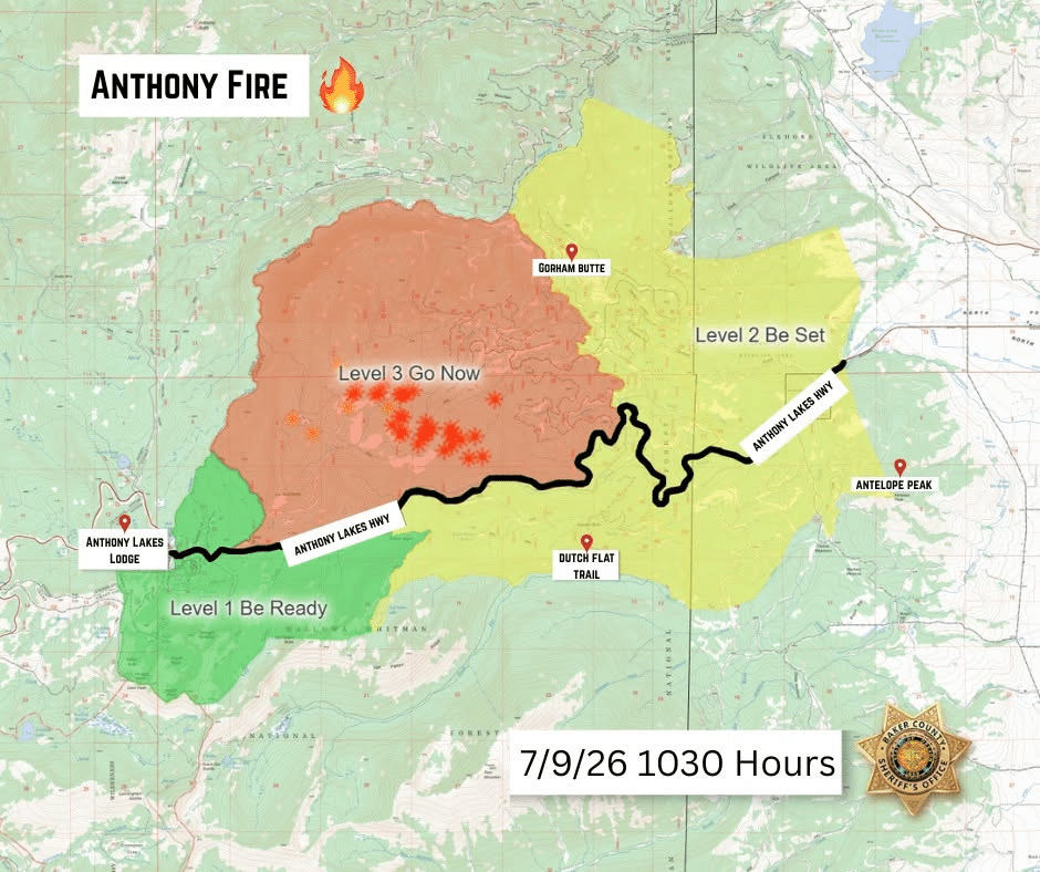
(UPDATE 7/9/10AM): The Anthony Fire, a mile northwest of Grande Ronde Lake in Baker County, was last updated at 400 acres with firefighting resources engaged.
On Wednesday, the Baker County Sheriff’s Office issued Level 1 (BE READY) evacuation notices for Anthony Lakes, Mud Lake, Floodwater Flats and surrounding areas. Find the evacuation map, along with information from the Baker County Sheriff’s Office below:
*****
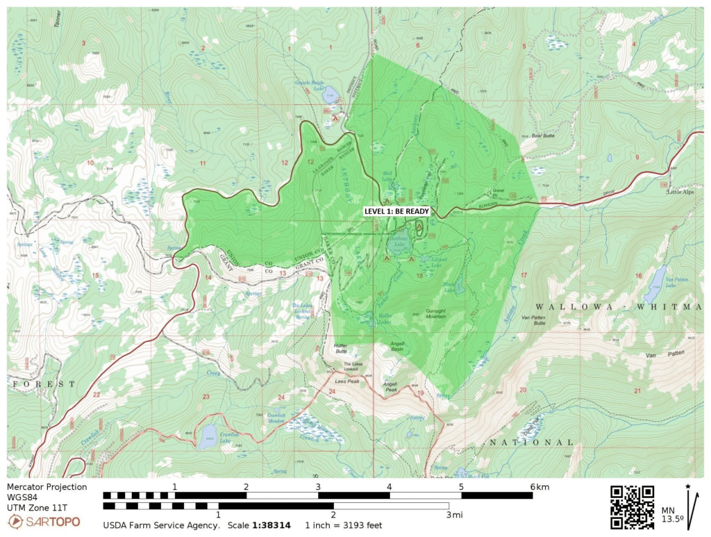
PREVIOUS –BAKER COUNTY — (Notice from the Baker County Sheriff’s Office) A fire has been reported approximately 2 miles north of Anthony Lakes.
Baker County Sheriff’s Office has issued the following evacuations:
Level 1 (BE READY): Anthony Lakes, Mud Lake, Floodwater Flats and surrounding areas
Baker County Sheriff’s Office search and rescue members are responding to the area to assist with evacuation notifications
**
(Map provided by Union County Emergency Services)