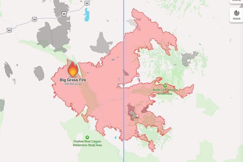
Big Grass Fire incident update as of August 5, 2026
By Mindy McKerrall on Wednesday, August 5th, 2026 in Eastern/Southeast Oregon News Eastern/Southeast Oregon Top Stories
MALHEUR COUNTY- Location: 25 miles SW of Jordan Valley, Acres Burned: 358,959, Containment: 35%, State Date: July 23,2026, Cause: lightning, Personnel: 959.
An aggressive full-suppression strategy is in place for the Big Grass Fire to protect communities, structures, critical infrastructure, and other valuable resources at risk. Efforts are focused on minimizing impacts on public, private, and state lands, as well as natural and cultural resources. This is being done in coordination with the local Rangeland Fire Protection Association (RFPA) and cooperating agencies.
Current Situation: Yesterday, fire officials announced that the west side of the fire showed no signs of active fire near containment lines and is now in Patrol Status, which allows firefighting resources to be redirected to other critical areas.
Firefighters will continue to patrol the region and monitor for any potential problem areas.
On the northern perimeter in the Boulder Creek Area and on the eastern perimeter, north of Mud Flat Road, the fire remained very active due to higher temperatures and low relative humidity. Firefighting efforts continued to be focused on constructing both direct and indirect containment lines away from the fire’s edge. This strategy provides firefighters with the best opportunity to fight the fire defensively, particularly in areas where the terrain is steep and difficult to access.
Today, the northeast perimeter remains a priority for firefighters who are constructing an indirect containment line from the Combination and Rose Ridge areas southeast to the Josephine Road. This indirect line will connect to a dozer line near the edge of the fire and help reduce the overall fire footprint. Additionally, firefighters are focusing on the active fire spreading east along Mud Flat Road, with the goal of keeping it west of Josephine Road. Crews are also working to secure fire lines around ranches, private properties, and critical infrastructure in the South Mountain area.
Evacuations: Malheur County Emergency Management announced yesterday that all evacuation levels for the Jordan Valley area have been removed. The Owyhee County Sheriff issued a Level 3 GO evacuation order for Triangle Reservoir, Pleasant Valley, South Mountain, Pleasant Valley Road to the City of Triangle, City of Triangle to the Triangle Reservoir, Flint Creek Road, Juniper Mountain Road, and the west portion of Mud Flat Road. A Level 2 SET status has been issued for Silver City.
BLM Area Closure: Access to the North Fork Campground along Juniper Mountain Road in Owyhee County is temporarily closed. The entire area south of Trout Creek Road and Silver City Road to the East Fork and Main Stem of the Owyhee River and from the Oregon border east to Highway 78 and Highway 51 is also temporarily closed. These closures are necessary to ensure the safety of both the public and firefighters involved in suppression efforts. For more information on BLM area closures and maps, visit: BLM Oregon Closures.
Weather and Air Quality: Today, high pressure is building over the desert Southwest, leading to a return of very hot and dry conditions in the area through the upcoming weekend. Thursday and Friday are expected to be the hottest days, with afternoon high temperatures ranging from the 90s to low 100s. Relative humidity will drop into the single digits each afternoon. Degraded air quality will persist over the area. For more information on Air Quality at your location, visit
www.airnow.gov for real-time data.
Cooperating Agencies: Jordan Valley RFPA, Owyhee RFPA, Malheur County Sheriff’s Office, Owyhee County Sheriff’s Office, Owyhee County OEM, Idaho OEM, ODT, Idaho Power, Idaho Department of Lands.