Northwest Team 12 takes over 1,000-acre Salmon Fire
By Logan Bagett on Friday, July 10th, 2026 in Eastern/Southeast Oregon News Eastern/Southeast Oregon Top Stories Northeastern Oregon News Northeastern Oregon Top Stories


GREENHORN, OR – UPDATE (7/10 12:50 p.m. from Umatilla National Forest)
Northwest Team 12 was briefed yesterday and took command of the Salmon Fire along with Caribou Fire, Cow Meadow Fire, Olive Butte Fire, Vinegar Hill Fire, Clear Creek Fire and Buck Gulch Fires early this morning.
The team is setting up an InciWeb page for the Salmon Fire and a Facebook can be found at https://www.facebook.com/SalmonFireOR2026/ and will have information posted this afternoon.
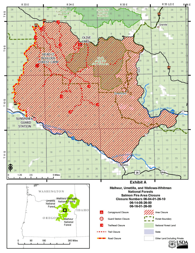
Forest officials have a temporary area closure for public safety and to facilitate firefighting operations in the area surrounding. The orders can be found on any of the three forests websites.
Traffic on State Highway 7, County Road 20, County Road 503, National Forest Service (NFS) Roads 10, 13, and 1305 around closure area remain open to through traffic and are not impacted by this closure. NFS Road 45 is closed for public access.
The Salmon Fire is still estimated at 1,000 acres and crews are continuing to improve the line to protect the community of Greenhorn.
Weather: Weather is expected to be similar to what has happened since this incident started with winds blowing out of the northwest at 8 to 12 mph with gusts up to 20 mph. The combination of predicted winds, low relative humidities and fuel loading in the area is a concern for firefighters.
A Temporary Flight Restriction (TFR) of 7 nautical miles centered around Vinegar Peak surrounds the Salmon Fire. The area is required for aircraft to safely maneuver.
If You Fly, We Can’t! Please remember unauthorized drone flights can shut down aerial firefighting operations, making fires grow larger, threatening more lives, property, and critical habitats.
A level 3 evacuation notice for the Greenhorn area is still in effect by Baker County Sheriff’s Office.
The public is asked to avoid the area for everyone’s safety and to facilitate the firefighting efforts.
Officials want to remind everyone that the current fire danger rating is at MODERATE and as of this morning Public Use Restricts Phase A are in effect for Umatilla National Forest.
For the latest information regarding smoke and air quality see https://fire.airnow.gov/
For more information regarding Restrictions, please contact:
Umatilla National Forest:
Information Hotline: Toll-Free (877) 958-9663
www.facebook.com/UmatillaNF
X: @UmatillaNF
Additional information about the Umatilla National Forest is available at: http://www.fs.usda.gov/umatilla
*****
UPDATE (7/9/26 from the Baker County Sheriff’s Office)
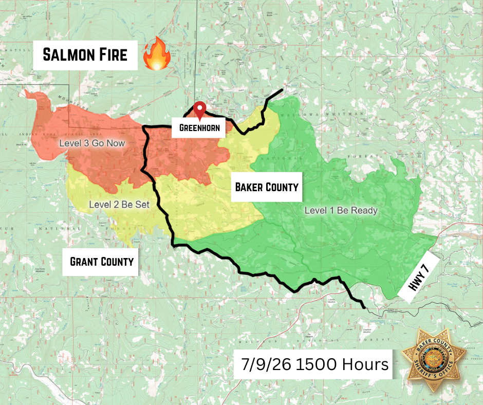
A new and expanded evacuation map has been issued for the Salmon Fire (formerly the Greenhorn Fire) by the Baker County Sheriff’s Office. See the new map below:
*****
UPDATE (7/9/26 from the Umatilla National Forest):
Yesterday afternoon the Salmon and Greenhorn Fires merged into one fire and will now be referred to as the Salmon Fire. Officials have ordered a Complex Incident Management Team which will transition with the current Incident Management Team tomorrow morning at 6 am. They will be managing the Salmon Fire along with the Caribou Fire, Cow Meadow Fire, Olive Butte Fire, and Vinegar Hill Fire.
Forest officials will soon issue a temporary area closure around the fires for public safety and to facilitate firefighting operations.
The Salmon Fire is now estimated at 1,000 acres, and crews are working on improving the line to protect the community of Greenhorn.
Weather: Weather is expected to be similar to what happened yesterday with winds that are predicted to increase in the afternoon blowing out of the northwest at 8 to 15 mph with gusts up to 22 mph after 3:00 pm. The combination of predicted winds, low relative humidities and fuel loading in the area is a concern for firefighters.
A Temporary Flight Restriction (TFR) of 7 nautical miles centered around Vinegar Peak surrounds the Salmon Fire. The area is required for the aircraft to safely maneuver.
If You Fly, We Can’t! Please remember unauthorized drone flights can shut down aerial firefighting operations, making fires grow larger, threatening more lives, property, and critical habitats.
A level 3 evacuation notice for the Greenhorn area was issued by Baker County and is still in effect.
The public is asked to avoid the area for everyone’s safety and to facilitate firefighting efforts.
Officials want to remind everyone that the current fire danger rating is at MODERATE for Umatilla National Forest.
For the latest information regarding smoke and air quality see https://fire.airnow.gov/.
*****
UPDATE (7/9/26 @ 9:30AM):
The Oregon State Fire Marshal has mobilized two structural task forces through Immediate Response to the community of Greenhorn. The Baker County Sheriff’s Office has Level 3 evacuations in place for the Greenhorn Fire, updated Thursday morning to 108.1 acres. The nearby Salmon Fire was updated at just under 230 acres.
The public is asked to avoid the area for everyone’s safety and to facilitate the firefighting efforts.
Yesterday morning, the Baker Fire Defense Board Chief and county commissioners requested assistance to help protect homes and critical infrastructure. The Fire Marshal is sending two task forces from Lane and Yamhill counties, and a division supervisor from Portland Fire & Rescue.
*****
UPDATE (7/8/26 2:40PM):
(From the Umatilla National Forest)
Multiple thunderstorms passed over the Greenhorn area last evening igniting several fires on the southeastern corner of the Umatilla National Forest and on the Malheur National Forest. Two of these fires are currently burning near Greenhorn.
The Salmon Fire, estimated at 10 acres, is burning half a mile to the northwest of Greenhorn in heavy dead and down fuels and subalpine fir. This is on the boundary of the North Fork John Day Wilderness. Last night’s observed fire behavior included torching of small groups of trees and 2-5 ft flame lengths through the ground fuels. Crews are on scene and working to bring heavy equipment to the fireline where feasible. Aircraft including heavy helicopters and air attack have been ordered.
The Greenhorn Fire, estimated at 10 acres, is also burning in dead and down fuels with subalpine fir. This fire is about 1.5 miles to the west of Greenhorn. Active fire behavior was seen until 3:00 am with torching and 2-5 ft flame lengths. Crews are working this morning to gain access with heavy equipment.
Winds are predicted to increase this afternoon blowing out of the northwest at 8 to 15 mph with gusts up to 22 mph after 3:00 pm. The combination of predicted winds, low relative humidities and fuel loading in the area is a concern for firefighters.
A level 3 evacuation notice for the Greenhorn area was issued by Baker County and is currently in effect.
The public is asked to avoid the area for everyone’s safety and to facilitate the firefighting efforts.
Officials want to remind everyone that the current fire danger rating is at MODERATE for Umatilla National Forest.
For the latest information regarding smoke and air quality see https://fire.airnow.gov/
For more information regarding Restrictions, please contact:
Umatilla National Forest:
Information Hotline: Toll-Free (877) 958-9663
www.facebook.com/UmatillaNF
X: @UmatillaNF
The latest fire information will be posted on the Blue Mountains Fire Information Blog. To receive updates on fires in the Blue Mountains, follow our blog at http://bluemountainfireinfo.blogspot.com/.
Additional information about the Umatilla National Forest is available at: https://www.fs.usda.gov/umatilla
*****
UPDATE (7/8/26 10:20AM):
(From the Baker County Sheriff’s Office)
Evacuation levels for Greenhorn remain at Level 3 (GO NOW). No new orders have been issued. Additional structure protection crews have been requested.
*****
PREVIOUS (7/7/2026): (From Baker County Sheriff’s Office)
A fire has been reported near Greenhorn.
Baker County Sheriff’s Office has issued the following evacuations:
Level 3 (GO NOW): Greenhorn
Baker County Sheriff’s Office deputies and search and rescue members are in the area to conduct door-to-door notifications.
Fire resources are on scene to provide structure protection.