8-30 Update: Paradise and Hagen fires
By Terry Murry on Sunday, August 30th, 2026 in Columbia Basin News Columbia Basin Top Stories Northeastern Oregon News Northeastern Oregon Top Stories
From the Southern Area 3 Incident Command Team:
August 30, 2026
| PUBLIC SAFETY: Evacuation levels change quickly. Please check official sources often. | |||
| Fire | Size* | Containment | Personnel |
| Hagen | 60,861 acres | 35% | 827 |
| Paradise | 9,324 acres | 15% | 496 |
*Our reported acreage comes from the ICS-209, the official source used across all incident updates and posted on InciWeb to maintain consistency. Infrared mapping flights often occur overnight and can produce updated perimeter data that appears sooner on platforms like Watch Duty. Those numbers can sometimes be useful for situational awareness, but we publish only the acreage that has been verified for accuracy.
KEY MESSAGES
- Limited tactical firing operations today. Firefighters may perform tactical firing in portions of the southern area of the Hagen Fire today and tonight. Burning is not planned for the Paradise Fire.
- Thank you, Oregon National Guard. Aviation resources from the Oregon National Guard were released yesterday from the Hagen and Paradise Fires. The Southern Area Team 3 would like to thank them for their service on behalf of all on-the-ground firefighters and the Umatilla National Forest.
- Welcome Partners from Australia and New Zealand. Yesterday, several individuals joined firefighting efforts on the Hagen and Paradise Fires, from crews to public information officers. We want to thank them for traveling thousands of miles to help.
- Hunting season is underway. For public safety, hunters and visitors are urged to respect all forest closures and remain alert. Firefighters and equipment may be operating outside of the immediate operating fire area miles away from the actual fire perimeter.
CURRENT CONDITIONS AND PLANNED ACTIVITIES
Paradise Fire
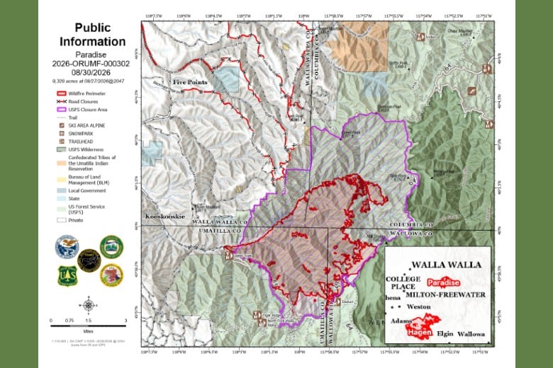
As with previous operational periods, firefighters continue to secure and mop up firelines, especially along the Mill Creek drainage and close to the intake, near Forest Service Road 65 and next to other existing control lines. They will also continue to prepare areas where containment lines can be safely strengthened. As crews secure these areas, containment percentages will increase.
Hagen Fire
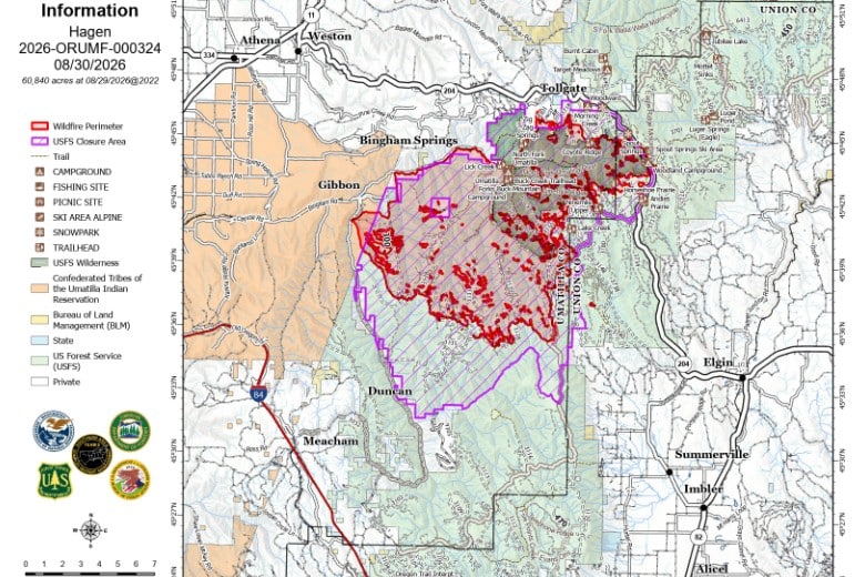
Fire personnel continue to secure and mop up firelines across the area, especially along Highway 204. Crews will continue mopping up along Forest Service Road 3128 today. Tactical burning operations are possible along the fire’s southern edge today, tonight and into tomorrow. Aviation assets will continue to support work on the ground.
WEATHER AND FIRE BEHAVIOR Temperatures will start chilly but climb to the mid to low 70s. Relative humidity will be slightly lower than yesterday, 26-30%. Winds will be 5-10 mph in the morning, with gusts peaking around 15-18 mph in the afternoon. Modest fire activity is expected.
Map of Paradise Fire above and Hagen Fire below from Southern Area 3 Incident Command Team